Texas

Coffee News® in Texas
Affordable advertising in Texas.
Discover affordable advertising in Texas. Advertise in your local community.
Advertising Rates, Readers’ Contests, and What’s Happening events are all managed by your local publishers. To contact the Coffee News publisher closest to you use our listing below.
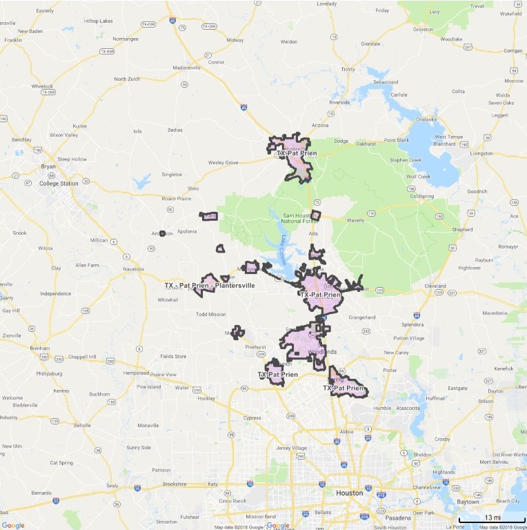
Pat Prein and Coco Phillips
www.texascoffeenews.com
836-656-5801
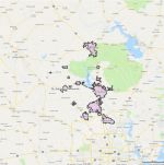
Coverage Area
- Conroe
- Montgomery
- Willis
- Huntsville
- New Waverly
- The Woodlands
- Magnolia
- Spring
- Tomball
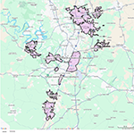
Boundary Map – Click to view full size map.
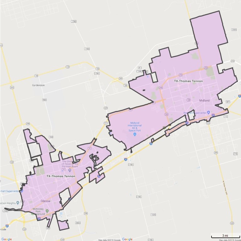
Thomas K. Tennon
Coverage Area
- Midland
- Odessa
Boundary Map – Click to view full size map.
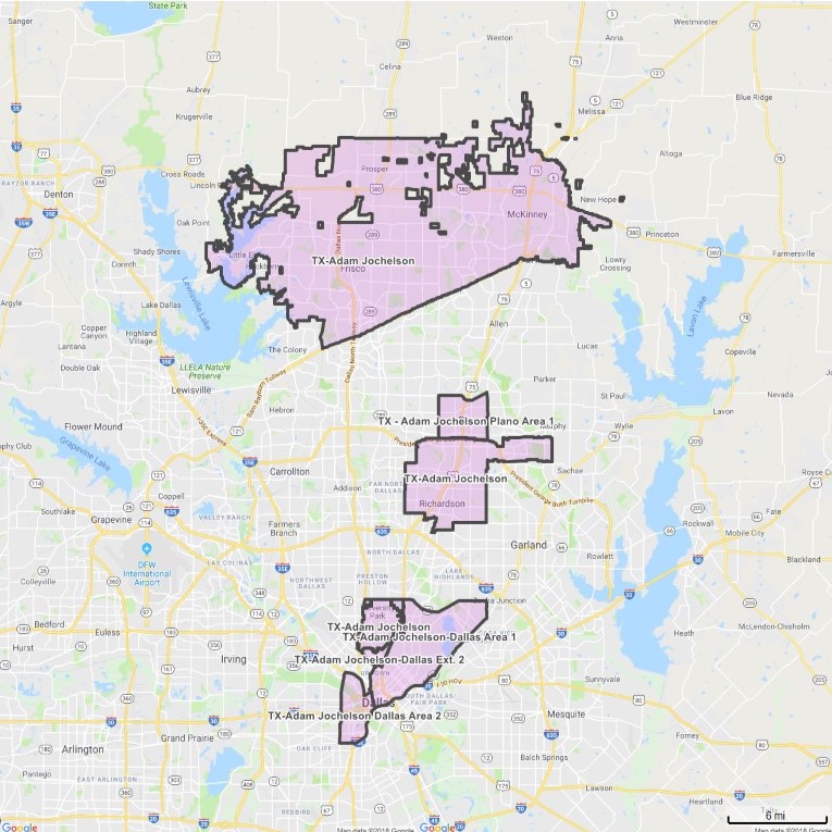
Adam Jochelson
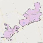
Coverage Area
- University Park
- Highland Park
- Richardson
- Frisco
- Prosper
- McKinney
- Little Elm
Boundary Map – Click to view full size map.
Dallas, TX Area 1
North: Northwest HWY at HWY 75 on the west. Headed east along Northwest HWY to Jupiter Rd. on the east.
South: I-30 at Griffin St on the west. Headed east along I-30 to E. Grand Ave on the east.
East: Jupiter Rd. at Northwest HWY on the north. Headed south along Jupiter Rd. to Garland Road (78). Headed south along Garland Rd (78) to E. Grand Ave. Headed south along E. Grand Ave to I-30 on the south.
West: HWY 75 at Northwest HWY on the north. Headed south along HWY 75 to E. Lovers Lane. Headed east along E. Lovers Lane to Greenville Ave. Headed south along Greenville Ave. to E. Mockingbird Lane. Headed west along E. Mockingbird Lane to HWY 75. Headed south along HWY 75 to Blackburn St. Headed west along Blackburn St to Cole Ave. Headed south along Cole Ave. to Carlisle St. Headed south along Carlisle St. to Cedar Springs Rd. Headed south along Cedar Springs Rd. to N. Field St. Headed south along N. Field St. to N. Griffin St. Headed south along N. Griffin St. to S. Griffin St. Headed south along S. Griffin St. to I-30 on the south.
Dallas, TX Area 1 Ext. 1
North: West Northwest Highway (12) at Dallas North Tollway on the west. Headed east along West Northwest Highway (12) to the University Park City Limits on the east.
South: University Park City Limits at Dallas North Tollway on the west. Headed east along University Park City Limits to University Park City Limits on the east.
East: University Park City Limits at West Northwest Highway (12) on the north. Headed south along University Park City Limits to University Park City Limits on the south.
West: Dallas North Tollway at West. Northwest Highway (12) on the north. Headed south along Dallas North Tollway to University Park City Limits at Greenbriar Drive.
Dallas, TX Area 1 Ext. 2
North: West Northwest Highway (12) at the University Park City Limits at Airline Rd on the west. Headed east along West Northwest Highway (12) to HWY 75 on the east.
South: Lemmon Ave at the Highland Park City Limits on the west. Headed east along Lemmon Ave to Cole Ave on the east.
East: HWY 75 at West Northwest Highway (12) on the north. Headed south along HWY 75 to E. Lovers Lane. Headed East along E. Lovers Lane to Greenville Ave. Headed south along Greenville Ave. to E Mockingbird Lane. Headed west along E. Mockingbird Lane to HWY 75. Headed south along HWY 75 to Blackburn St. Headed west along Blackburn St. to Cole Ave. Headed southwest along Cole Ave. to Lemmon Ave on the south.
West: University Park City Limits at West Northwest Highway (12) on the north. Headed south along University Park City Limits to the Highland Park City Limits. Headed south and west along the Highland Park City Limits to Lemmon Ave. on the south.
Dallas, TX Area 2
North: HWY 35E at Wycliff Ave on the west. Headed east along HWY 35E to Route 366 on the east. Headed east along route 366 to N. Griffin St. on the east.
South: W 12th St at N Tyler St on the west. Headed east along W 12th St to HWY 35E on the east.
East: N Griffin St at Route 366 on the north. Headed south along N. Griffin St to South Griffin St. Headed along South Griffin St to HWY 30. Headed south along HWY 30 to HWY 35E. Headed south along HWY 35E to W. 12th St. on the south.
West: Wycliff Ave at HWY 35E on the north. Headed south along Wycliff Ave to Sylvan Ave. Headed south along Sylvan Ave. to N Tyler St. Headed south along N Tyler St to W 12th St on the south.
Plano, TX Area 1
North: W. Parker Rd. at Custer Rd. on the west. Headed east along W. Parker Rd. to Jupiter Rd. on the east.
South: President George Bush Turnpike at Custer Rd. on the west. Headed east along President George Bush Turnpike to Jupiter on the east.
East: Jupiter Rd. at W. Parker Rd. on the north. Headed south along Jupiter Rd. to President George Bush Turnpike on the south.
West: Custer Rd. at W. Parker Rd. on the north. Headed south along Custer Rd. to President George Bush Turnpike on the south.
Genesis Cautivar
Click here to email
www.coffeenewsgp.com
214-497-3592
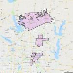
Coverage Area
- Mansfield
- Venus
- Grand Prairie
Boundary Map – Click to view full size map.
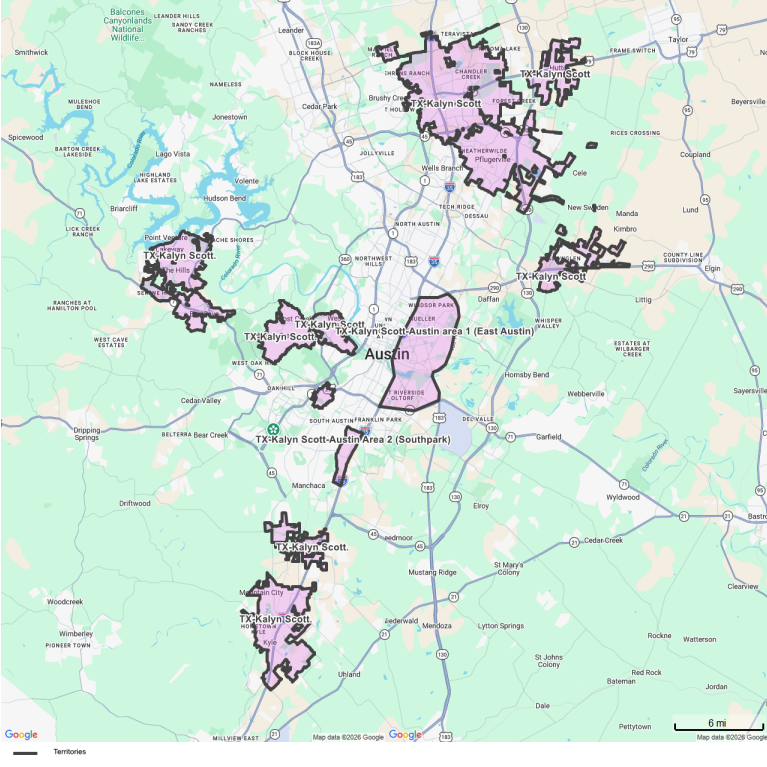
Kalyn Scott
Click here to email
214-504-8165
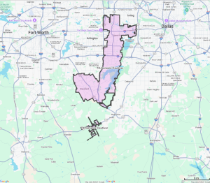
Coverage Area
- Roundrock
- Hutto
- Pflugerville
- Manor
- Lakeway
- The Hill
- Bee Cave
- Lost Creek
- Barton Creek
- West Lake Hills
- Rollingwood
- Sunset Valley
- Buda
- Kyle
- Mountain City
Boundary Map – Click to view full size map.
Austin, TX Area 1 (Austin East)
North: E. Hwy 290 at North Interstate Hwy 35 on the west. Headed east along E. Hwy 290 to Ed Bluestein Blvd (183) on the east.
South: E. Ben White Blvd. at North Interstate Hwy 35 on the west. Headed east along E. Ben White Blvd. to Ed Bluestein Blvd (183) on the east.
East: Ed Bluestein Blvd (183) at E. Hwy 290 on the north. Headed south along Ed Bluestein Blvd (183) to E. Ben White Blvd. on the south.
West: North Interstate Hwy 35 at E. Hwy 290 on the north. Headed south along North Interstate Hwy 35 to E. Ben White Blvd. on the south.
*Includes distribution locations along both sides of the outer boundary streets.
Austin, TX Area 2 (Southpark)
North: W. William Cannon Drive at S. 1st St. on the west. Headed east along W. William Cannon Drive to Purple Heart Trail/Monarch HWY (35) on the east.
South: 1626 at S. 1st St. on the west. Headed east along 1626 to Purple Heart Trail/Monarch HWY (35) on the east.
East: Purple Heart Trail/Monarch HWY (35) on the east at W. William Cannon Drive on the north. Headed south along Purple Heart Trail/Monarch HWY (35) to 1626 on the south.
West: S. 1st St. at W. William Cannon Drive on the north. Headed south along S. 1st St. to 1626 on the south.
*Includes distribution locations along both sides of the outer boundary streets.
Other USA Locations
- Alabama
- Alaska
- Arizona
- Arkansas
- California
- Colorado
- Connecticut
- Delaware
- Florida
- Georgia
- Hawaii
- Idaho
- Illinois
- Indiana
- Iowa
- Kansas
- Kentucky
- Louisiana
- Maine
- Maryland
- Massachusetts
- Michigan
- Minnesota
- Mississippi
- Missouri
- Montana
- Nebraska
- Nevada
- New Hampshire
- New Jersey
- New Mexico
- New York
- North Carolina
- North Dakota
- Ohio
- Oklahoma
- Oregon
- Pennsylvania
- Rhode Island
- South Carolina
- South Dakota
- Tennessee
- Texas
- Utah
- Vermont
- Virginia
- Washington
- West Virginia
- Wisconsin
- Wyoming
Interested in more than a single location? For inquiries on statewide or nationwide advertising information, please contact us by phone or using our Inquiry Form. Click here to go to our contact page.


Population and number of restaurants will vary from market to market, but typically areas of under 50,000 population provide ideal conditions single edition territories.